I don't commute along the Gardiners Creek Trail these days, so the alterations and improvements that were made to the path during the M1 Upgrade in 2008–2009 have appeared fresh to me on the handful of occasions that I've ridden that way in the last few months. Of course you can't miss some of the changes, like the new artificial wetland and bridge that now stands where a derelict bowling green languished. And there is a welcome realignment near Valley Road, that improves the width, grade and visibility of the path.
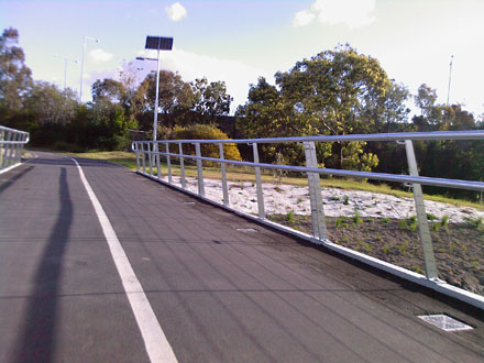 A new bridge and artificial wetlands
When all of the improvements that have taken place over the last four or five years are taken into account, from East Malvern through to the Yarra River, the Gardiners Creek Trail is now a high-quality shared path.
But as an occasional visitor to the Trail, what I find really interesting is how it contrasts Boroondara's positive support for cycling with Stonnington's rather less encouraging approach, as the path meanders back and forth across the municipal boundary between the two council jurisdictions.
1. Infantilise the path user
The simplest illustration is the difference in treatment of the road crossing at Dunlop St. On one side, it's Boroondara:
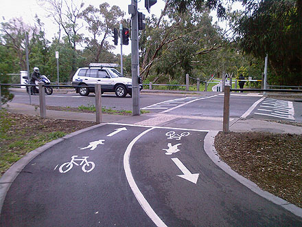 This approach says, 'We trust you to do the right thing.'
In Boroondara, they expect path users (both cyclist and pedestrian) to be aware and sensible enough to stop at the edge of the road, so painted markings are enough to mark the intersection. But for the same conditions at the same location, Stonnington believes in treating path users like children:
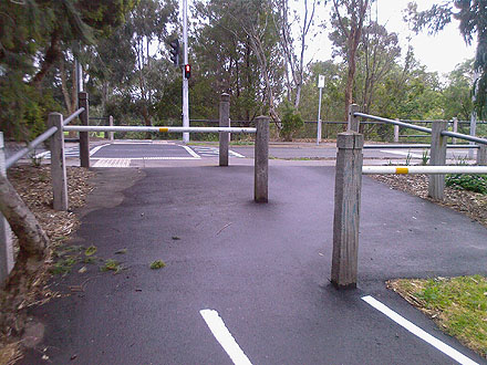 This approach says, 'We think you're too stupid to keep yourself safe.'
Clearly we can't be trusted to look after ourselves so there's a pointless dog-leg gate. In fact, these things are worse than pointless, I believe they are downright dangerous. As I've said previously:
when you approach an intersection, your attention should be on traffic in the road ahead not on negotiating an obstacle course. I have nothing to back this but I suspect that Boroondara Council is gradually removing or altering such barriers at road crossings, probably for the very reason that they are an illusion: they don't really improve safety.
It's true: there was an identical dog-leg gate on the Boroondara side of this crossing but when they resurfaced this section of the path in 2007, the gate was removed.
2. Obstruct the path user
Despite it being common knowledge and well documented that bollards and other obstacles in the middle of the path are hazardous to cyclists, Stonnington has seen fit to install two at this point where the path enters Brixton Rise in Glen Iris:
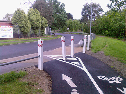 Bollards? Seriously? How very last century!
The intention is clearly to create a traffic island effect with lanes separation, but there isn't enough space and it doesn't work. And for the life of me I can't understand why the Council thought this was a good and useful idea. It's just an obstacle that increases the risk of collision and is a distraction for riders as they enter the roadway, when their attention should be on cross-traffic on the road.
Interestingly, this complex arrangement of bollards was absent when this ramp was renovated a few years ago—then there was just a single bloody stupid post in the middle of the path. I'm not sure what's worse. At least these new ones are more visible.
Along with dog-leg gates, Boroondara has long ago removed all bollards from the path on its side of the creek.
3. Misdirect the path user
This one is the sneakiest of all. Stonnington has widened and resurfaced the Trail as is runs alongside the Malvern Valley Golf Course between Winton Road and the Solway Street bridge, complete with nice new line markings and more runway lights—in itself that's all very welcome:
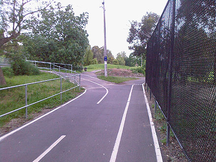 Nice new surface, lines and lights.
Look—they have even created a dedicated "Golfers Only" express lane:
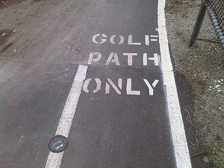 Designed for narrow golf buggies…
How special. But notice that the line markings direct traffic off to the left here. And pointing in that direction the small blue indicator sign on the lamp post says "Anniversary Trail". Presumably the right-hand branch just goes off into the golf course? And the "Golf Path Only" marking right at that branch might make you think so. But no, that's actually the link to the Scotchmans Creek Trail, by far the busier route for bike commuters than the Anniversary Trail.
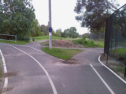 Hmm, am I even allowed to turn right here?
Let's see where each of these branches lead. Firstly, the left branch to the Anniversary Trail:
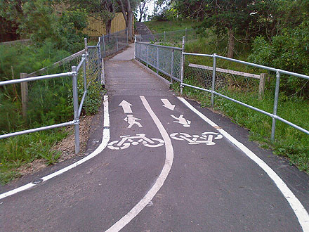 Yep, it's narrow and rickety.
This is the Solway Street Bridge. Yes, the same one that was closed for over a year and then not replaced. It's narrow and rickety, and leads to a nasty little steep pinch up to road grade at the other side.
Now let's see what's around the corner of the right-hand branch to Scotchmans Creek Trail:
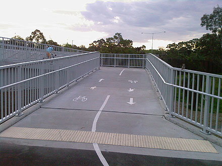 Well-made, wide bridge…
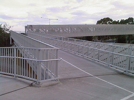 …with gentle grades and wide flat corners
The bridge over the Monash Freeway was installed last year and (although not perfect) is a very bike-friendly overpass.
So when you consider that at the intersection above, the bulk of the bike traffic heads to/from the Scotchmans Creek Trail via an excellent new bridge, why does Stonnington Council install line marking and signage that heavily suggest path users can only go the other way—over a really crappy bridge?
I don't think you need to be too jaded to think that Stonnington Council is hoping that path users will magically adhere to the laughable Master Plan for Gardiners Creek, which will force path users to make a hilly detour via the Anniversary Trail to get to the eastern section of the Gardiners Creek Trail on the other side of Warrigal Road. (Incidentally, there is $2.5 million of Federal Government funds available to build this sub-optimal route.)
Stonnington has always opposed the most direct and logical route for closing the gap between Solway Bridge and Warrigal Road which would go through the Golf Course on the south bank of Gardiners Creek. And I think Stonnington would be happier if no cyclists went through the Golf Course at all, hence the lack of signage and line markings to indicate the route to Scotchman's Creek Trail. Frankly it looks sneaky and dishonest, and it plays cyclists for fools. And that just about sums up Stonnington Council's corporate attitude to cyclists.
Thanks for that. They are all small things, but added together they look like a pattern of disrespect or a least disregard for the interests of cyclists.
Stonnington is the council that seems to equate bike path with "no need to do road maintenance" as well.
I've crashed into that dogleg at Dunlop rd when with a group of folks - all it takes is one person to not quite manage the sharp turn, and suddenly its a tangle of wheels and legs.
The bollards are bad, but the ones in Monash along Scotchman's creek are even worse - they are dark colour, and often have no reflectors.
Don't get me started on the Scotchmans Creek Trail! As I've said before, that's a trail that could do with some improvement.
[This comment has been moved and republished as a separate post. See Stonnington's utter contempt.]
I think some of these qualify as crap cycle lanes. I shall make a link. Good photos.
@crapcyclelanes If that's the case, you might also want to include the Scotchmans Creek Trail...
Nice post, but as for no. 2 - the bollards are not to separate cyclists - they are to stop vehicles (bogans in hotted up boy racer cars) driving on the bike lanes.
I think you would agree that the nuisance of having to look out for bollards is worth it for the benefit of not having cars driving on the bike lanes!
I tried to ride the loop Koonung / Main Yarra / Capital City/Gardiniers/Scotchmans/Dandinong/Eastlink /Mullum Mullum/Koonung a few weeks back and found the Gardiniers onto Scotchmans section to be most confusing - Signage was lacking in so many places - and completely missing are those spray on track marks that are common on the other routes (And which would make your #3 misdirection much easier to figure out from a distance.)
I actually gave up on Scotchmans and rode down Waverly Road - I know there are sections of on road on scotchmans trail - but the signage could be so much better at so many points that it just became an exercise in frustration.
For example - Herriotts Glen Reserve - "Scotchmans" does a loop around this reserve that brings you right back where you started - strangely this section seemed to be rather well sign posted whereas the actual trail itself (eg how to stop going around in a 1km loop) didn't seem well very clear at all.
@Jack's liver: Actually, no I don't agree. I urge you to go back and read the article Bollards & obstacles in the middle and end of paths on the Bicycle Network Victoria web site. The key message is that these things represent a serious injury hazard while often being limited in effectiveness or not needed at all. To quote the VicRoads cycle note on the topic:
A common method of restricting access to unauthorised vehicles is to install a bollard in the centre of the path. This type of treatment creates an unacceptable risk to cyclists and should only be used when there is no other alternative available.
(my emphasis added)
And also:
In some instances, it may be necessary to install terminal treatments to prevent access by unauthorised vehicles into road reserves and parklands…However, before a terminal treatment is installed there must be clear evidence that such access is occurring and the treatment must be effective at preventing access by these vehicles.
(my emphasis added)
There are a number of other places along Gardiners Creek where cars could enter parkland (e.g. Glenferrie Road, Great Valley Road, Dunlop Street, Winton Road) but there appears to be no evidence that there is a problem with motor vehicles on parkland in this area. I have never seen tyre tracks in any of the parks and the only motor vehicles I have ever seen driving on trails in this area were authorised maintenance or works vehicles.
Basically, the problem that the bollard in Brixton Rise is trying to solve doesn't exist. To quote BNV's comment about another path bollard, "Its one remaining property is as a hazard to bike riders."
@Warwick: Oh yeah, Scotchmans Creek Trail is a shocker. I don't ride that way very often but I haven't noticed much work done along there in recent times, other than a very good realignment near the Oakleigh Pool.
I didn't even know that Scotchmans Creek Trail went into Herriotts Glen Reserve (in fact, I had to look up where Herriotts Glen Reserve is). The route from where the trail comes out onto Waverley Rd near the Holmesglen TAFE through to Jells Park is convoluted and mostly on-road. And if you don't know where you're going, your chances of staying on the route by following signs is slim. And that's a shame, because if you don't mind riding the back streets, it's actually quite a pleasant route.
Speaking of signage, I've always found it puzzling that the trail has signs showing it going in three directions at the corner of Rhonda Street and Anthony Drive.
Comments
Great post; the difference between those two approaches is so stark isn't it, and the respect for cyclists (and lack of it) so clear.