I was contacted recently with the following query:
I am visiting Melbourne (from the UK) in March and am trying to decide how best to explore Melbourne and surrounding areas, and I am quite sure that a day's bike ride would be fantastic! Would you be willing to recommend routes and possibly bike rental shops?
Sure, my suggestions are:
A brief outline of each follows. I have mentioned possible bike hire outlets for information only—I make no recommendations (cafés on the other hand…)
It might be worth getting hold of the TravelSmart Map or the bike paths guide for more information.
Ride 1: The Capital City Trail
Probably the best way to sample much of what Melbourne has to offer the recreational cyclist can be found on the Capital City Trail. About 30km, it loops around the inner suburbs of Melbourne entirely on off-road shared paths, taking you on a tour from downtown Melbourne through some of the best parks in the city. It also includes part of the excellent Yarra Trail—ride on the north bank of the river to try the floating path.
- Notes and maps
- Map at bikely.com
- Trail notes by Bicycle Network
- Suggested starting points
- Docklands (bike hire: Rentabike @ Docklands)
- Federation Square (bike hire: Rentabike @ Federation Wharf)
- It's a loop so start wherever you like…
- I recommend that you tackle the eastern part of the route first.
- Tips
- Stop for coffee at The Collingwood Children's Farm, Nicholson Street, or Southbank.
- Detour to Studley Park for a picnic lunch by the river or take coffee (or ice cream) at the Boathouse
- Grab some deli items in Nicholson Street then ride on to Royal Park for a gourmet picnic
- You can cut the ride short by heading south at Princes Park, keeping the Melbourne Cemetary and University of Melbourne on your left and you will head straight back through the centre of the city.
- Gotchas
- This route includes the infamous Abbotsford Steps a flight of 41 steps near the end of Gipps Street—compulsory dismount and if you have a child in a kiddie seat, please take them out before ascending/descending!
- There is a steep descent (when heading north) under Heidelberg Road at Yarra Bend Park—not really dangerous but take it easy, and watch out immediately after this: the trail gets a bit narrow after you've gone under the road bridge.
- Some low-lying bridges are subject to inundation after rain between Heidelberg Road and Rushall Station, and between Flemington Road and Footscray Road.
- There are frequent road crossings between Rushall Station and Princes Park.
- Webb Bridge at the southern end of Docklands Park is an architectural wonder and a dangerous and poorly thought-out obstacle course with a tight blind corner and central railings. Take it easy here.
- Docklands and Southbank are popular mixed-use precincts, very popular with pedestrians on sunny weekends, so ride to the conditions.
Ride 2: The Bay Trail
The most popular part of the Bay Trail runs from Port Melbourne to Ricketts Point (so popular is this section that much of it is a dedicated bike path, that is there are separate paths for bicycles and foot traffic). The Trail continues south as far as Seaford, but after Mordialloc turns inland away from the beachfront. It is possible to continue further south on the Peninsula Link trail.
Many people forget (or aren't even aware) that the Bay Trail also continues to the west of the Yarra River, through Williamstown to Altona Meadows. In the warmer weather things might be just a little quieter on that end of the Trail.
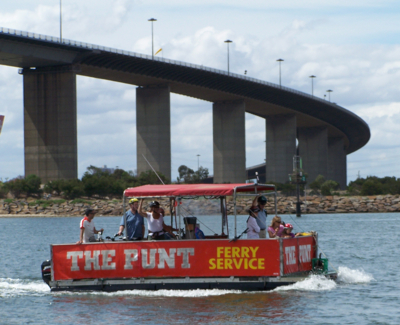 Take the punt
- Notes and maps
- Map of the eastern section on bikely.com
- The Bay Trail page at Bicycle Network
- Suggested starting points
- St Kilda (bike hire: St Kilda Cycles)
- Docklands or Federation Square as per Ride 1—head to the western end of Southbank Promenade, follow the bike trail from the corner of Spencer Street and Normanby Road (beside the light rail line) to Port Melbourne
- Take the train to Williamstown, Brighton, or Mordialloc
- There's about 70km of trail here, so start wherever you like and ride until you're ready to turn around.
- Tips
- The Bay Trail is a bit exposed, so if it's windy start off heading into the wind and let the tail wind bring you back.
- Take coffee at Ricketts Point, Acland Street or (if you fancy yourself to be hardcore enough) Café Racer.
- Head west: take the Westgate Punt and trundle on to beautiful Williamstown—coffee and cake, or picnic in the foreshore park. Then keep going around towards Altona.
- Gotchas
- The Bay Trail is very popular in warmer weather—from Port Melbourne to Brighton (but especially on the St Killda foreshore) the path can be very crowded.
- On the eastern arm there are numerous vehicular crossings to foreshore carparks, which also get busy in warmer weather.
- When heading south there is a steep-ish descent immediately before Ricketts Point with a car park entry at the bottom—take it slow.
- The Westgate Punt only runs 'on demand' on weekends and during commuter hours on weekdays (6.30am–9am, 4pm–6.40pm).
- Generally, it's hard to get lost: the path mostly stays pretty close to the beach, except under the Westgate Bridge and south of Mordialloc.
Ride 3: The Merri Creek Trail
The Merri Creek Trail is a very pleasant route along a tree-lined valley, running through inner northern suburbs of Melbourne. It separates from the Capital City Trail at Rushall Station. Cross the bridge to the east of Rushall Station, turn left into McLachlan St, then left into Cunningham St: the trail continues through a narrow exit at the end of the cul de sac.
- Notes and maps
- Notes on Wikipedia
- Map on bikely.com
- Suggested starting points
- Rushall Station
- Federation Square as per Ride 1—follow the Capital City Trail east then north to Rushall Station.
- Tips
- Take coffee or lunch at CERES Café.
- Have a picnic at Coburg Lake
- This can either be an out-and-back route or a longer loop by continuing on to the Moonee Ponds trail.
- Gotchas
- None that I can recall (but I haven't been that way for a while).
- Watch out for the occasional blind corner.
- The path swaps from one side of the creek to another, but isn't too hard to follow as it stays close by the creek.
Ride 4: Warburton Rail Trail
On the outskirts of Melbourne's urban sprawl, about 40km of abandoned railway line have been converted into a picturesque ride in the country. The Lilydale-Warburton Rail Trail is a very well maintained gravel path that follows the old railway reserve from the edge of suburbia to the foot of Mt Donna Buang.
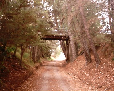 Rail trail with all the cuttings
- Notes and maps
- Notes and map by Rail Trails Australia
- Notes on Wikipedia
- Map on bikely.com
- Suggested starting points
- Lilydale can be reached by train (bike hire: Yarra Valley Cycles)
- Mt Evelyn would require a car or the 663 bus from Lilydale
- The Launching Place Pub and Yarra Junction Recreation Reserve are also possible starting points for those who can drive there
- Warburton (bike hire: Cog Café)
- Tips
- Penny Olive Sourdough Café at Mt Evelyn is almost impossible to ride past!
- There is a good pie shop in Woori Yallock
- Warburton has some very pleasant picnic areas and several fine eating options
- Gotchas
- No major complaints here: all road crossings have warning sign posts and the path is well maintained
- Some folks find the steady climb from Woori Yallock up to Mt Evelyn a bit tedious at the end of the day but it's at railway gradient, so it's not what you'd call steep, just constant.
- I find the gateway barriers a bit low and have the potential to be a collision hazard [update: these days most have been removed or are keep folded down]
- Watch the water supply if the weather is warm: there aren't too many refill opportunities
Comments
Thanks, duly updated. Yes, it's now a better deal to get the punt on a weekday.
The Westgate Punt ferry runs on weekdays as well, but only in peak hours (6:30-9:00 am, 4:00 - 6:40 pm). On the upside - it's only $2 on weekdays!
Yeah, I'd forgotten the bike shop and repair business at Cogs. I guess it's just a question of whether it's a bike shop with a sideline in coffee, or a café that does bike repairs. Or maybe it's both equally? I really must get up there sometime soon.
Cogs Cafe not only has good coffee and muffins but also is a real bike repair shop with accessories for sale at prices that are cheaper than most City bikeshops. I like to stop at it going and coming.
ozz is right—in fact I've been considering the route around loop he suggests, but it's not something I'd include on a list like this: it would be a bit long and more a ride to say you've done it than for sightseeing (I can't imagine that all of the trail along Eastlink is going to be picture postcard material).
And the big question for Charlie is, was he on the trike at the time he was munching a muffin? And if so, would he recommend the technique for two-wheelers? :-)
The reason for going east first on the Capital City Trail is simple: because the western part of the trail (from Flemington Road to Docklands) is the flattest part of the route it's best left to the end.
I had initially intended to say that you should go anticlockwise, but then I did say start wherever you like and if you start somewhere like Royal Park that's not good advice. So, in general, the guideline is to head east and leave the western section to the end of the ride.
Actually the Bay trail goes further south than Mordialloc. It crosses Patterson River in Carrum and ends in Seaford.
http://en.wikipedia.org/wiki/Bayside_Trail
When Eastlink is completed near year it should be possible to do a 90+ km loop starting in the Melbourne CBD, heading south via Brighton to Patterson Lakes, then turn left and head towards Dandenong, travelling through Glen Waverley and Mitcham and back towards the city via the Eastern Fwy trail. Not exactly scenic for the entire distance, but it would certainly demonstrate how much the bike trail network has progressed over the years...
Did the Warburton Trail last Saturday. Great route. And in the Lilydale-Warburton direction, you can pick up a very tasty muffin at Cog, and eat it while coasting the long long downhill. :-)
You recommend that you start the Capital City Trail in an easterly direction. Since you also say to start wherever you like, would you recommend clockwise or counterclockwise?
Heading east from Federation Square would be counterclockwise.
I recently went to Melbourne to review the Capital City Trail for bikingtrails.com.au. Managed to ride it in one afternoon but the 39km ride might have ended up a 50km ride. As it was hard at times to figure out which side of the Yarra I should be on. So there was a bit of back tracking. When I finish the review and maps I will post it on my site. Hopefully that will be helpful to some riders. Especially tourists to Melbourne like me. Dave.
Excellent article!
The Warburton Trail is great.
When I was living at the back of Cadel Evans Mum's place in Arthurs Creek, used to see him regularly drive the whole Hurstbridge, Kangaroo ground, Kinglake roads.