The Rosstown Railway Heritage Trail is more of a suggested route than an established trail in the usual sense. It runs in a (roughly) straight line between Elsternwick and Oakleigh railway stations, a route once taken by the failed Rosstown Railway. Originally constructed in the 1880s to transport sugar to the ports from Murray Ross's sugar beet mill in Murrumbeena, it was never operational and was decommissioned in 1916.
There's nothing really spectacular about the Rosstown Trail—certainly no notable relics of the long defunct railway—it's just an easy, pleasant route through pleasant, picturesque suburbs. Ideal for a weekend trundle, the Trail also provides a possible cross-country link between the Bay Trail and several other trails including the Outer Circle Rail Trail to the north-ish, Gardiners Creek and Scotchman's Creek Trails to the east, as well as the route south along the Dandenong railway line to Westall Station. So it could easily be included as part of a longer circuit.
Considerations and hazards
The route follows quiet back streets and involves numerous crossings at busy north-south roads, so it's probably not a suitable ride for young kids or large groups. I reckon about a third of the route is covered by off-road bike paths, but I prefer to ride it all on the adjacent roads.
As these are residential suburbs there are often parked cars down both sides of the street, so the usual warning about the door zone applies. A specific problem in back streets is that both drivers and riders tend to relax in the relatively lighter traffic, sometimes leading to a lack of attention at roundabouts and other intersections: watch out for drivers who blithely roll through intersections (and don't do the same).
Following the Trail
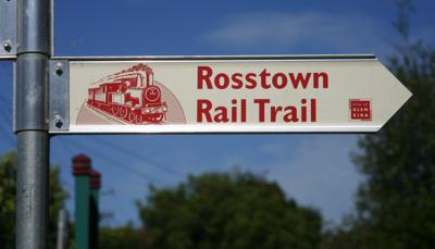
The route is marked out with distinctive pointer signs (which are sometimes missing at important road crossings) and also by blue bike route symbols and arrows.
Rail Trails Australia and the City of Glen Eira both provide good maps, and the Glen Eira pamphlet is very informative on the history of the railway. Its description of the route starts at Elsternwick, so I've started at Hughesdale and described it in the opposite direction. I've also included a connecting route through to the Bay Trail via the Elwood Canal. Melways references are in [square brackets].
Murrumbeena
Start at the level crossing at Hughesdale Station [69 C6], taking the pathway on the south side that runs between the shops and the railway line. This shortly bring you to Galbally Reserve, where there is a playground. This is roughly the point where the Rosstown Railway joined onto the Oakleigh line. Take the right-hand branch of the path, which leads onto Freda St and then to Poath Rd. Turn left into Poath Rd then right at the roundabout at Kangaroo Rd [69 C7]. Immediately beside the service station, turn left into Murrumbeena Crescent—a long, wide sweeping curve that must surely be a disused railway line—then at Murrumbeena Rd [69 A7] cross almost directly into Rosanna St.

There's a little dog-leg bend where Judd St joins from the left then at Koornang Rd [68 H7] turn left then right at the roundabout into Oakleigh Rd. (Ross's sugar beet mill was located near what is now Koornang Rd just north of the intersection with Rosanna St.)
Carnegie and Caulfield South

Go straight across at Grange Rd [68 F7] where a linear park (Oakleigh Rd Reserve) runs parallel to the road. At the end of Oakleigh Rd go under the railway line on Dorothy Ave [68 E7] (via an underpass that Ross was required to build for his railway).

On the other side, turn left into E. E. Gunn reserve, ride in front of the stands (watch for broken glass here, especially around the end of the footy season!) and continue onto Beatty Crescent, with the reserve along the road on the right. At Booran Rd [68 D7] cross almost directly into Marara Rd, where the reserve continues on the right. Halfway along this reserve, at Narrawong Rd, there is a rather dull monument to Murray Ross—the last physical reminder of his failed dream:

Now that you've read it, you won't have to worry about stopping to have a look. Take Dover St which is to the right across Bambra Rd [68 B6] with Princes Park beyond.

At Hawthorn Rd [68 A6] turn right (watch those tram tracks!), then take the next left into Aileen St. You'll pull the same trick at Kooyong Rd [67 J5]: right then next left into Clarence St., where St Catherine's Anglican Church is a dominant landmark.

(If Elsternwick station [67 F3] is your destination, continue straight on Clarence St: it becomes Riddell Pde, which goes directly to the station.)
Elster Creek
Leave the Rail Trail and continue to the Elster Creek and Elwood Canal by turning left at Brentani Ave [67 F5] and left again into St. James Pde. Just before reaching the Nepean Highway the ramp to a pedestrian overpass rises to the right.

Cross the overpass and on the other side turn left and go through the tunnel under the railway line; the Elster Creek is straight ahead so follow the narrow pathway which leads that way.

The path is a narrow concrete strip but at Head St [67 F6] it continues unsealed and usually with a fair smattering of broken glass—you might want to turn left into Head St then right into Murphy St (the second roundabout) and rejoin the trail at the other end of Elsternwick Primary School [67 E5].

(Incidentally, if you're heading south on the Bay Trail, you might want to skip the Elwood Canal by staying on Head St all the way to the beach at Elwood Park [67 C5].)
If you decide to stay on the unsealed trail, you'll have to bounce down the bluestone kerb onto the road at Murphy St at the north end of Elsternwick Primary School.
Elwood Canal
Straight ahead at the New Street roundabout—Elsternwick Park on the left, Elsternwick Golf Course on the right— then turn right at the roundabout into St Kilda St. Spray St comes in from the left and there is a gateway that leads onto the Elwood Canal path.

From here you follow your nose (literally, if the day is warm and the water level is low!) down to the Bay Trail. You need to cross onto the north bank of the Canal at Glenhuntly Rd [67 C3] (a busy road with a narrow traffic island) and then back to the south bank shortly afterwards.

There are a number of road crossings along the Canal where visibility is limited until the last moment (especially going in the other direction) and these seemingly quiet streets can be quite busy, so take it easy.